Tanbark Trail & Tin House

If you’ve got at least half a day, here is another great hike that will take you through a wide variety of Big Sur environments.
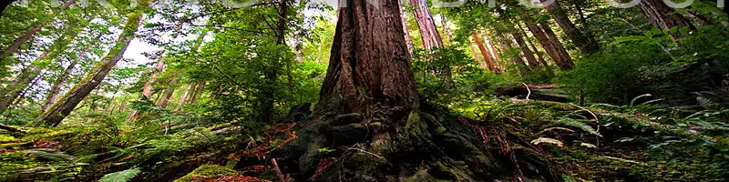
The Tanbark Trail starts off in a redwood forest along Partington Creek, then lifts you 1,600 feet through the oaks and eventually drops down on the abandoned Tin House. You then continue down a fire road with fantastic coastal views, and walk up Highway 1 back to your car.
Hike Facts:
• Length: 5.6 miles
• Type: Loop
• Difficulty: Strenuous
• Path: Steep, good
• Elev. Gain: 1,600 feet
• Parking Fee: No
• Restrooms: No

Tanbark Trail Map

The Hike
After parking, look for the guardrail along the apex of the turn on the east side of Highway 1.
Starting points for the Tanbark Trail (sometimes referred to as the Tan Bark Trail or Tan Oak Trail) can be found on either the left or right side of the guardrail/creek.

Either one will do, however we prefer starting at the left or northern trailhead, since the other one crosses a huge boulder slide.
If you start at the left trailhead, you’ll quickly come to a bridge that crosses south over Partington Creek and joins up with the main trail. If you start at the right trailhead, climb over the pile of boulders that have slid down the hill, and head towards the tall redwoods.

You’ll now be hiking inland along the southern bank of the creek in a very scenic canyon filled with redwoods, ferns and huge rock outcroppings. If you only want a short forest hike, this canyon makes a great destination by itself, and you can venture just a half mile or so in.
As you continue, the trail gets noticeably steeper and switches back and forth a couple times up the canyon wall. At this point you’ll be seeing an increasing number of tanbark oaks, many dying as a result of “sudden oak death” which started showing up in the mid-90s.
Unfortunately, one result of the epidemic is a number of diseased trees falling across the trail, which is often blocked in several spots by fallen trunks or limbs. These deadfalls are easy enough to get around and are often removed, but others will likely replace them.
A little less than a mile in, at the spot where the trail hooks to the right past a sign that says “Donald H. McLaughlin Grove,” look over to the left and up. A few feet off the path is a trio of unique twisty redwoods (pictured at right) whose bark spirals upward around the trunk of each tree.

A couple more switchbacks and you are now heading east for a long and steady uphill stretch of trail that eventually crosses the south fork of Partington Creek in an area known as Swiss Camp, about 2 miles from the trailhead. Here you’ll see the clearest evidence of where Gunder Bergstrom piled stones to reinforce short stretches of path in the 1920s and formed a bridge back over the creek heading southwest.
There is also a bench under the huge redwoods at this spot and this is a great place to stop for lunch or rest before making the final ascent to the Tin House.

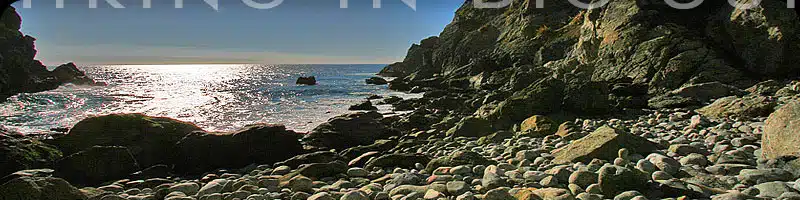
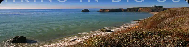
The final uphill stretch of the Tanbark Trail tops out at the junction for the Tin House, where the trail itself ends at a fire road at about 3 miles from the start. Take the road left for a short hop down to the Tin House and a spectacular view of the coast, especially north towards Partington Canyon.
The Tin House has an interesting history and was built in 1944 by Lathrop Brown, a former Congressman from New York, who also built the home above McWay Falls that was finally removed in 1965. The tin sheeting and parts came from two old gas stations, and the house was fully finished inside with rich blue walls in the living room.
The story goes that when the house was completed, the Browns spent one night there and soon discovered that the tin structure made a lot of noise as it expanded and shrank with the temperature changes. They never returned.

The house itself is clearly crumbling, but you can peer into the openings and doors and see each room with blinds still on some of the windows and electrical sockets in the walls. What’s remarkable is that though the house faces the ocean, the main windows look up and down the coast, but not directly out towards the water.
After you are done exploring the Tin House and area, head back up the fire road to where it meets the end of the Tanbark Trail and head left down the well-graded road a couple miles to the coast. The fire road is quite steep, and will eventually emerge from the trees to allow great southern views of the ocean and Highway 1.

At the bottom, cross the road to the scenic view overlook and head north along the west side of Highway 1. It is less than a mile back to the start of the Tanbark Trail and the parking area.
Alternate Exploring
If you are looking for a more direct path up to the Tin House, consider taking the fire road straight up from the highway. Be aware that though it’s almost a mile shorter, this is a much steeper path than the Tanbark Trail, and not nearly as interesting (apart from the great views at the beginning).
If you did park at the Partington Canyon turnout (and are not already worn out), then consider taking the short hike down to Partington Cove starting on the ocean side of the highway.
Getting There
The Tanbark Trail starts at a large pullout in a sweeping bend on the inland side of Highway 1. You can park on either side of the highway—on the west side there is a road down to Partington Cove with a gate at top.
The pullout is just 2 miles north of the Julia Pfeiffer Burns State Park turnoff, or 54.6 miles north of the Hearst Castle turnoff.
Travelling south on Highway 1, the pullout is 9 miles south of Pfeiffer Big Sur State Park Entrance or exactly 6 miles south of Nepenthe Restaurant.