Ragged Point Fire Road Trail

This uphill hike is all about the views and changing terrain since there are no redwood groves or rushing streams.
You’ll get a good workout on a well maintained fire road where the views get better all the way to the top. This is also the southern-most “Big Sur” hike and starts right across the road from the Ragged Point Inn.
Hike Facts
• Length: 4 miles
• Type: Up & Back
• Difficulty: Moderate
• Path: Graded Fire Road
• Elev. Gain: 1700′
• Parking Fee: No
• Restrooms: Yes

Ragged Point Fire Road Trail Map

The Hike
I’ve yet to find an official name for this hike/road, so we’ll refer to it as the Ragged Point Fire Road trail.
According to the USDA Forest Service map, this fire road is within the very southern tip of the Las Padres National Forest, but just south of the Silver Peak Wilderness area. It is often used by campers coming down from the San Carpoforo, Turkey Springs or Dutra Flat campgrounds.
Once you’ve found the gate a few feet east of the highway, proceed up the wide and well graded gravel road to the northeast. Near the beginning of the trail you’ll see a branch to the left that heads back to the Ragged Point Inn parking lot.

Right away you’ll start your ascent, and this trail simply goes up, up, up. It never gets terribly steep, but the climb is unrelenting and rarely levels out. This, of course, makes for a rather quick downhill descent after reaching the turnaround.
The beginning of the trail is fairly open, with several small but dramatic stands of cypress trees on either side. There are also a few oak groves along the path, but this hike is generally out in the open all the way up, so could prove a challenge on a hot, sunny day.

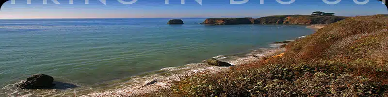
The fire road crosses a couple of small seasonal streams, and you’ll go through one additional gate. There are great views across to adjacent canyons all along the way, and a little past the halfway point is a wonderful overlook that takes in the ocean and rolling hills. This is followed by a grander overlook higher up, and then another.
The hills up here are gorgeous, and while the trees can be sparse in places, every direction offers great scenery. Some of the best large moss and lichen covered boulders can be found in these hills.
Eventually the road/trail ends at a T intersection, where another road/trail branches north and south, connecting up with several campsites. This is our turnaround spot for the trek back downhill.
Alternate Exploring
Since this trail starts across from the Ragged Point Inn, it’s a no-brainer to head west to take in the views on the property. From the parking lot, go past the restrooms and follow the path under the trees for a few hundred feet.
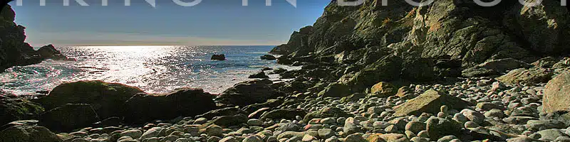
There is also a short, but challenging, trail down to the beach below the Inn on the north side of the big lawn (they call it Pirate’s Cove). If you’ve got the time and nimble feet, this is well worth the effort. Don’t try it in wet weather.
Getting There
The Ragged Point Fire Road begins on the east side of Highway 1, about 100 yards south of the Ragged Point Inn turnoff. Look for an obvious gate just a few feet off the road nestled under some trees. There is a US Department of Agriculture Forest Service sign next to the gate (see photo at right).
There are several pullouts on the west side of the highway near the fire road, or you can park in the Ragged Point Inn parking lot. If you park in the parking lot, there is a gate and trail directly across the road from the entrance that heads south and quickly joins up with the fire road.
Travelling south on Highway 1, the Ragged Point Inn is 48.6 miles south of Pfeiffer Big Sur State Park Entrance or 11.5 miles south of Gorda. The Ragged Point Inn is 15 miles north of the Hearst Castle turnoff.
Links To More Information
• Where this trail lies along the Big Sur coast
• Ragged Point Inn & Restaurant